Categories
Earth & Climate Events Feature Fossils & Ruins Learning & Education Plants & Animals Researcher news Student researchers

Ancient “Sea Monsters” Reveal How the Ever-Changing Planet Shapes Life, Past and Present

Never-Before-Seen Fossils From Angola Bring a Strange Yet Familiar Ocean Into View

The Smithsonian’s National Museum of Natural History will open a new exhibition Nov. 9, 2018 revealing how millions of years ago, large-scale natural forces created the conditions for real-life sea monsters to thrive in the South Atlantic Ocean basin shortly after it formed. “Sea Monsters Unearthed: Life in Angola’s Ancient Seas” will offer visitors the opportunity to dive into Cretaceous Angola’s cool coastal waters, examine the fossils of striking marine reptiles that once lived there and learn about the forces that continue to mold life in the ocean and on land.

Over 134 million years ago, the South Atlantic Ocean basin did not yet exist. Africa and South America were one contiguous landmass on the verge of separating. As the two continents drifted apart, an entirely new marine environment — the South Atlantic — emerged in the vast space created between them. This newly formed ocean basin would soon be colonized by a dizzying array of ferocious predators and an abundance of other lifeforms seizing the opportunity presented by a new ocean habitat.

“Because of our planet’s ever-shifting geology, Angola’s coastal cliffs contain the fossil remains of marine creatures from the prehistoric South Atlantic,” said Kirk Johnson, the Sant Director of the museum. “We are honored by the generosity of the Angolan people for sharing a window into this part of the Earth’s unfolding story with our visitors.”

For the first time, Angolan fossils of colossal Cretaceous marine reptiles will be on public display. Through Projecto PaleoAngola — a collaboration between Angolan, American, Portuguese and Dutch researchers focused on Angola’s rich fossil history — paleontologists excavated and studied these fossils, which were then prepared for the exhibition by a team of scientists and students at Southern Methodist University (SMU) in Dallas. The exhibition was made possible by the Sant Ocean Hall Endowment Fund.

“Fossils tell us about the life that once lived on Earth, and how the environments that came before us evolve over time,” said Louis Jacobs, professor emeritus of paleontology at SMU and collaborating curator for the exhibition. “Our planet has been running natural experiments on what shapes environments, and thereby life, for millions of years. If it weren’t for the fossil record, we wouldn’t understand what drives the story of life on our planet.”

The exhibition will immerse visitors in this Cretaceous environment with lively animations and vivid paleoart murals of life beneath the waves — courtesy of natural history artist Karen Carr — that bring to life 11 authentic fossils from Angola’s ancient seas, full-size fossil reconstructions of a mosasaur and an ancient sea turtle, as well as 3-D scanned replicas of mosasaur skulls. Photomurals and video vignettes will transport visitors to field sites along Angola’s modern rugged coast, where Projecto PaleoAngola scientists unearth the fossil remains from this lost world.

A Strange but Familiar Ocean
“Sea Monsters Unearthed” paints the picture of a flourishing ocean environment that in some ways will look strange to modern eyes, yet still bears striking similarities to today’s marine ecosystems.

Peculiar plesiosaurs — massive reptiles with long necks, stout bodies and four large flippers — swam alongside 27-foot-long toothy marine lizards called mosasaurs and more familiar creatures like sea turtles. From surprising mosasaur stomach contents to the one of the oldest known sea turtles found in Africa, fossils and reconstructions of these species will offer visitors a fuller picture of their remarkable life histories and the ecosystems they were a part of.

The exhibition will also explore deeper similarities across the ecology and anatomy of ocean animals then and now. After the marine reptiles that dominated these waters went extinct 66 million years ago, modern marine mammals would not only later replace them as top predators in the world’s ocean, but also converge on many of the same body shapes and survival strategies.

The Forces That Shape Life, Then and Now
This unique period in Earth’s history reveals how key geologic and environmental forces contributed to the early establishment and evolution of life in the South Atlantic. As Africa and South America drifted apart and a new ocean basin formed, trade winds blowing along the new Angolan coastline created the conditions for upwelling, an ocean process that drives the circulation of nutrients from the deep ocean to its surface. These nutrients in turn jump-started the food web that attracted the ferocious marine reptile predators featured throughout the exhibition.

Just as tectonic forces helped create this Cretaceous marine environment, they also shaped the arid coastal cliffs where the fossils are found today. Starting 45,000 years ago, a geologic process called uplift caused Earth’s crust to bulge along Angola’s coast, lifting part of the seafloor out of the water — and along with it, the layers upon layers of fossil-filled rocks where Projecto PaleoAngola scientists work.

Though humans do not operate on a tectonic scale, their actions also have major impacts on ocean life. Humans are now the ocean’s top predators, with one-fifth of the world’s population relying on food from upwelling-based ecosystems. Scientists caution that with such great pressure on modern upwelling-based fisheries, overfishing could change the future of life in the ocean by threatening fish populations, marine ecosystems and even human health. — National Museum of Natural History

About the National Museum of Natural History
The National Museum of Natural History is connecting people everywhere with Earth’s unfolding story. The museum is one of the most visited natural history museums in the world with approximately 7 million annual visitors from the U.S. and around the world. Opened in 1910, the museum is dedicated to maintaining and preserving the world’s most extensive collection of natural history specimens and human artifacts. It is open daily from 10 a.m. to 5:30 p.m. (closed Dec. 25). Admission is free. For more information, visit the museum on its website and on Facebook and Twitter.

Categories
Earth & Climate Energy & Matter Researcher news SMU In The News Student researchers Videos

WFAA Verify: Is West Texas sinking?

A new research report, from Southern Methodist University and funded by NASA, found a “…large swath of West Texas oil patch is heaving and sinking at alarming rates.”

WFAA-TV Channel 8’s Verify journalist David Schechter covered the phenomenon of the ground sinking at alarming rates in West Texas, according to the research of SMU geophysicists Zhong Lu, professor, Shuler-Foscue Chair, and Jin-Woo Kim research scientist, both in the Roy M. Huffington Department of Earth Sciences.

The Dedman College researchers are co-authors of a new analysis using satellite radar images that discovered decades of oil production activity in West Texas have destabilized localities in an area of about 4,000 square miles populated by small towns, roadways and a vast network of oil and gas pipelines and storage tanks.

Schechter’s WFAA ABC report, “Verify: Is West Texas sinking?” aired April 18, 2018.

Lu and Kim reported their findings in the Nature publication Scientific Reports, in the article “Association between localized geohazards in West Texas and human activities, recognized by Sentinel-1A/B satellite radar imagery.”

The researchers analyzed satellite radar images that were made public by the European Space Agency, and supplemented that with oil activity data from the Railroad Commission of Texas.

The study is among the first of its kind to identify small-scale deformation signals over a vast region by drawing from big data sets spanning a number of years and then adding supplementary information.

The research is supported by the NASA Earth Surface and Interior Program, and the Shuler-Foscue Endowment at SMU.

An earlier study by the researchers revealed significant ground movement of two giant sinkholes near Wink, Texas. The SMU geophysicists found that the movement suggests the two existing holes are expanding, and new ones are forming as nearby subsidence occurs at an alarming rate.

Watch the WFAA Verify news segment.

EXCERPT:

By David Schechter
WFAA-TV Verify

A new research report, from Southern Methodist University and funded by NASA, found a “…large swath of West Texas oil patch is heaving and sinking at alarming rates.”

To find out if West Texas is sinking, first I’m going to the guy who wrote the report, Dr. Zhong Lu. He’s a geophysicist who studies the earth using satellites.

By shooting a radar beam from space — like a measuring stick — a satellite can calculate elevation changes down to the centimeter. Lu did that over a 4000 square mile area.

“This area is sinking at half meter per year,” Dr. Lu says.

That’s more than a foot-and-a-half. Lu says, that’s alarming because that much change to the earth’s surface might normally take millions of years.

One of the images in his reports shows an area of sinking earth, near Wink, TX from 2011. Five years later, the satellite shows the sunken area had spread almost 240%.

“In this area that you are studying, is oil and gas the cause of the sinking?” I ask.

“Related to the oil and gas activities,” he says.

“Oil and gas activity is causing the sinking in West Texas?” I clarify.

“Yes,” he says.

Watch the WFAA Verify news segment.

Categories
Earth & Climate Energy & Matter Researcher news SMU In The News Student researchers

The Guardian: Texas sinkholes — oil and gas drilling increases threat, scientists warn

Ground rising and falling in region that has been ‘punctured like a pin cushion’ since the 1940s, new study finds.

The Guardian and other news outlets covered the West Texas sinkhole and ground movement research of SMU geophysicists Zhong Lu, professor, Shuler-Foscue Chair, and Jin-Woo Kim research scientist, both in the Roy M. Huffington Department of Earth Sciences at SMU.

The Dedman College researchers are co-authors of a new analysis using satellite radar images that shows decades of oil production activity in West Texas have destabilized localities in an area of about 4,000 square miles populated by small towns, roadways and a vast network of oil and gas pipelines and storage tanks.

An earlier study by the researchers revealed significant ground movement of two giant sinkholes near Wink, Texas. The SMU geophysicists found that the movement suggests the two existing holes are expanding, and new ones are forming as nearby subsidence occurs at an alarming rate.

The Guardian article by journalist Tom Dart was published March 27, 2018, “Texas sinkholes: oil and gas drilling increases threat, scientists warn.”

Other coverage includes articles by Forbes, Tech Times, Phys.org, Ecowatch, Fox San Antonio, The Dallas Morning News and the Texas Tribune.

Others include EarthSky.org, Live Science, KERA News, San Antonio Express, Houston Chronicle, Science Daily, The Energy Mix, Digital Journal, Homeland Security News Wire and the Science Bulletin.

Lu is world-renowned for leading scientists in InSAR applications, short for a technique called interferometric synthetic aperture radar, to detect surface changes that aren’t visible to the naked eye. Lu is a member of the Science Definition Team for the dedicated U.S. and Indian NASA-ISRO InSAR mission, set for launch in 2020 to study hazards and global environmental change.

InSAR accesses a series of images captured by a read-out radar instrument mounted on the orbiting satellite Sentinel-1A. Sentinel-1A was launched in April 2014 as part of the European Union’s Copernicus program.

Lu and Kim reported their latest findings in the Nature publication Scientific Reports, in the article “Association between localized geohazards in West Texas and human activities, recognized by Sentinel-1A/B satellite radar imagery.”

Lu and Kim reported the earlier findings in the scientific journal Remote Sensing, in the article “Ongoing deformation of sinkholes in Wink, Texas, observed by time-series Sentinel-1A SAR Interferometry.”

The research is supported by the U.S. Geological Survey Land Remote Sensing Program, the NASA Earth Surface & Interior Program, and the Shuler-Foscue Endowment at Southern Methodist University.

Read the full story.

EXCERPT:

By Tom Dart
The Guardian

Oil and gas activity is contributing to alarming land movements and a rising threat of sinkholes across a huge swath of west Texas, a new study suggests.

According to geophysicists from Southern Methodist University, the ground is rising and falling in a region that has been “punctured like a pin cushion with oil wells and injection wells since the 1940s”.

There were nearly 297,000 oil wells in Texas as of last month, according to the state regulator. Many are in the Permian Basin, described in a Bloomberg article last September as the “world’s hottest oil patch”.

But the Southern Methodist report warns of unstable land and the threat of sinkholes.

“These hazards represent a danger to residents, roads, railroads, levees, dams, and oil and gas pipelines, as well as potential pollution of ground water,” Zhong Lu, a professor, said in a statement.

Wink – a tiny town 400 miles west of Dallas best known as the childhood home of the singer Roy Orbison – attracted national headlines in 2016 when the same scientists warned that the land between two expanding sinkholes a mile apart was deteriorating, risking the formation of more sinkholes or even the creation of a colossal single hole.

Injection of wastewater and carbon dioxide increases pore pressure in rocks, a likely cause of uplift. Lu told the Guardian that cracks and corrosion from ageing wells may help explain the sinking.

A “subsidence bowl” near one of the Wink sinkholes has sunk at a rate of more than 15.5in a year, probably as a result of water leaks through abandoned wells causing salt layers to dissolve, the report found. Elsewhere, a lake formed after 2003 as a result of sinking ground and rising water.

Read the full story.

Categories
Earth & Climate Feature Researcher news Technology

Radar images show large swath of West Texas oil patch is heaving and sinking at alarming rates

Analysis indicates decades of oil production activity have destabilized localities in an area of about 4,000 square miles populated by small towns, roadways and a vast network of oil and gas pipelines and storage tanks

Two giant sinkholes near Wink, Texas, may just be the tip of the iceberg, according to a new study that found alarming rates of new ground movement extending far beyond the infamous sinkholes.

That’s the finding of a geophysical team from Southern Methodist University, Dallas that previously reported the rapid rate at which the sinkholes are expanding and new ones forming.

Now the team has discovered that various locations in large portions of four Texas counties are also sinking and uplifting.

Radar satellite images show significant movement of the ground across localities in a 4000-square-mile area — in one place as much as 40 inches over the past two-and-a-half years, say the geophysicists.

“The ground movement we’re seeing is not normal. The ground doesn’t typically do this without some cause,” said geophysicist Zhong Lu, a professor in the Roy M. Huffington Department of Earth Sciences at SMU and a global expert in satellite radar imagery analysis.

“These hazards represent a danger to residents, roads, railroads, levees, dams, and oil and gas pipelines, as well as potential pollution of ground water,” Lu said. “Proactive, continuous detailed monitoring from space is critical to secure the safety of people and property.”

The scientists made the discovery with analysis of medium-resolution (15 feet to 65 feet) radar imagery taken between November 2014 and April 2017. The images cover portions of four oil-patch counties where there’s heavy production of hydrocarbons from the oil-rich West Texas Permian Basin.

The imagery, coupled with oil-well production data from the Railroad Commission of Texas, suggests the area’s unstable ground is associated with decades of oil activity and its effect on rocks below the surface of the earth.

The SMU researchers caution that ground movement may extend beyond what radar observed in the four-county area. The entire region is highly vulnerable to human activity due to its geology — water-soluble salt and limestone formations, and shale formations.

“Our analysis looked at just this 4000-square-mile area,” said study co-author and research scientist Jin-Woo Kim, a research scientist in the SMU Department of Earth Sciences.

“We’re fairly certain that when we look further, and we are, that we’ll find there’s ground movement even beyond that,” Kim said. “This region of Texas has been punctured like a pin cushion with oil wells and injection wells since the 1940s and our findings associate that activity with ground movement.”

Lu, Shuler-Foscue Chair at SMU, and Kim reported their findings in the Nature publication Scientific Reports, in the article “Association between localized geohazards in West Texas and human activities, recognized by Sentinel-1A/B satellite radar imagery.”

The researchers analyzed satellite radar images that were made public by the European Space Agency, and supplemented that with oil activity data from the Railroad Commission of Texas.

The study is among the first of its kind to identify small-scale deformation signals over a vast region by drawing from big data sets spanning a number of years and then adding supplementary information.

The research is supported by the NASA Earth Surface and Interior Program, and the Shuler-Foscue Endowment at SMU.

Imagery captures changes that might otherwise go undetected
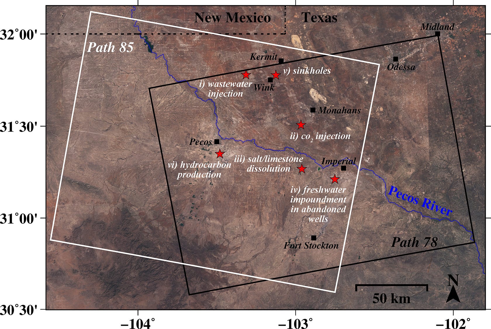
The SMU geophysicists focused their analysis on small, localized, rapidly developing hazardous ground movements in portions of Winkler, Ward, Reeves and Pecos counties, an area nearly the size of Connecticut. The study area includes the towns of Pecos, Monahans, Fort Stockton, Imperial, Wink and Kermit.

The images from the European Space Agency are the result of satellite radar interferometry from recently launched open-source orbiting satellites that make radar images freely available to the public.

With interferometric synthetic aperture radar, or InSAR for short, the satellites allow scientists to detect changes that aren’t visible to the naked eye and that might otherwise go undetected.

The satellite technology can capture ground deformation with an accuracy of sub-inches or better, at a spatial resolution of a few yards or better over thousands of miles, say the researchers.

Ground movement associated with oil activity
The SMU researchers found a significant relationship between ground movement and oil activities that include pressurized fluid injection into the region’s geologically unstable rock formations.

Fluid injection includes waste saltwater injection into nearby wells, and carbon dioxide flooding of depleting reservoirs to stimulate oil recovery.

Injected fluids increase the pore pressure in the rocks, and the release of the stress is followed by ground uplift. The researchers found that ground movement coincided with nearby sequences of wastewater injection rates and volume and CO2 injection in nearby wells.

Also related to the ground’s sinking and upheaval are dissolving salt formations due to freshwater leaking into abandoned underground oil facilities, as well as the extraction of oil.

Sinking and uplift detected from Wink to Fort Stockton
As might be expected, the most significant subsidence is about a half-mile east of the huge Wink No. 2 sinkhole, where there are two subsidence bowls, one of which has sunk more than 15.5 inches a year. The rapid sinking is most likely caused by water leaking through abandoned wells into the Salado formation and dissolving salt layers, threatening possible ground collapse.

At two wastewater injection wells 9.3 miles west of Wink and Kermit, the radar detected upheaval of about 2.1 inches that coincided with increases in injection volume. The injection wells extend about 4,921 feet to 5,577 feet deep into a sandstone formation.

In the vicinity of 11 CO2 injection wells nearly seven miles southwest of Monahans, the radar analysis detected surface uplift of more than 1 inch. The wells are about 2,460 feet to 2,657 feet deep. As with wastewater injection, CO2 injection increased pore pressure in the rocks, so when stress was relieved it was followed by uplift of about 1 inch at the surface.

The researchers also looked at an area 4.3 miles southwest of Imperial, where significant subsidence from fresh water flowing through cracked well casings, corroded steel pipes and unplugged abandoned wells has been widely reported.

Water there has leaked into the easily dissolved Salado formation, created voids, and caused the ground to sink and water to rise from the subsurface, including creating Boehmer Lake, which didn’t exist before 2003.

Radar analysis by the SMU team detected rapid subsidence ranging from three-fourths of an inch to nearly 4 inches around active wells, abandoned wells and orphaned wells.

“Movements around the roads and oil facilities to the southwest of Imperial, Texas, should be thoroughly monitored to mitigate potential catastrophes,” the researchers write in the study.

About 5.5 miles south of Pecos, their radar analysis detected more than 1 inch of subsidence near new wells drilled via hydraulic fracturing and in production since early 2015. There have also been six small earthquakes recorded there in recent years, suggesting the deformation of the ground generated accumulated stress and caused existing faults to slip.

“We have seen a surge of seismic activity around Pecos in the last five to six years. Before 2012, earthquakes had not been recorded there. At the same time, our results clearly indicate that ground deformation near Pecos is occurring,” Kim said. “Although earthquakes and surface subsidence could be coincidence, we cannot exclude the possibility that these earthquakes were induced by hydrocarbon production activities.”

Scientists: Boost the network of seismic stations to better detect activity
Kim stated the need for improved earthquake location and detection threshold through an expanded network of seismic stations, along with continuous surface monitoring with the demonstrated radar remote sensing methods.

“This is necessary to learn the cause of recent increased seismic activity,” Kim said. “Our efforts to continuously monitor West Texas with this advanced satellite technique can help sustain safe, ongoing oil production.”

Near real-time monitoring of ground deformation possible in a few years
The satellite radar datasets allowed the SMU geophysicists to detect both two-dimension east-west deformation of the ground, as well as vertical deformation.

Lu, a leading scientist in InSAR applications, is a member of the Science Team for the dedicated U.S. and Indian NASA-ISRO (called NISAR) InSAR mission, set for launch in 2021 to study hazards and global environmental change.

InSAR accesses a series of images captured by a read-out radar instrument mounted on the orbiting satellite Sentinel-1A/B. The satellites orbit 435 miles above the Earth’s surface. Sentinel-1A was launched in 2014 and Sentinel-1B in 2016 as part of the European Union’s Copernicus program.

The Sentinel-1A/B constellation bounces a radar signal off the earth, then records the signal as it bounces back, delivering measurements. The measurements allow geophysicists to determine the distance from the satellite to the ground, revealing how features on the Earth’s surface change over time.

“Near real-time monitoring of ground deformation at high spatial and temporal resolutions is possible in a few years, using multiple satellites such as Sentinel-1A/B, NISAR and others,” said Lu. “This will revolutionize our capability to characterize human-induced and natural hazards, and reduce their damage to humanity, infrastructure and the energy industry.” — Margaret Allen, SMU

Categories
Earth & Climate Energy & Matter Fossils & Ruins Researcher news SMU In The News

The Dallas Morning News: Earthquakes at DFW Airport continued for years after oil and gas wastewater well was shut

“Faults are not like a light switch – you don’t turn off a well and automatically stop triggering earthquakes.” — Heather DeShon, SMU seismologist.

Science journalist Anna Kuchment covered the earthquake research of a team of SMU seismologists led by SMU Associate Professor Heather DeShon and SMU Post-doctoral Researcher Paul Ogwari, who developed a unique method of data analysis that yielded the study results.

Kuchment wrote Earthquakes at DFW Airport continued for years after oil and gas wastewater well was shut for The Dallas Morning News.

The results of the analysis showed that efforts to stop human-caused earthquakes by shutting down wastewater injection wells that serve adjacent oil and gas fields may oversimplify the challenge. The seismologists analyzed a sequence of earthquakes at DFW Airport and found that even though wastewater injection was halted after a year, the earthquakes continued.

The sequence of quakes began in 2008, and wastewater injection was halted in 2009. But earthquakes continued for at least seven more years.

“This tells us that high-volume injection, even if it’s just for a short time, when it’s near a critically stressed fault, can induce long-lasting seismicity,” said Ogwari. The earthquakes may be continuing even now, he said.

The article by Kuchment, “Earthquakes at DFW Airport continued for years after oil and gas wastewater well was shut,” published Feb. 21, 2018.

Read the full story.

EXCERPT:

By Anna Kuchment
The Dallas Morning News

Earthquakes beneath DFW International Airport continued for seven years after an oil and gas company shut a nearby wastewater injection well that had been linked to the quakes, according to a new study by scientists at Southern Methodist University.

A wastewater well that continues to operate at the northern end of the airport – and which some area residents have said should be closed — was probably not involved in the events and poses little earthquake hazard, the researchers concluded.

“Faults are not like a light switch – you don’t turn off a well and automatically stop triggering earthquakes,” said Heather DeShon, a seismologist at Southern Methodist University and co-author of the paper, in an email.

The earthquakes at DFW Airport started on Halloween 2008, seven weeks after Chesapeake Energy began injecting wastewater into a well at the southern end of the airport. Scientists at SMU and the University of Texas at Austin investigated the quakes at the time and concluded they were most likely associated with the well.

Though Chesapeake shut its well in August 2009, earthquakes continued through at least the end of 2015. The largest, a 3.4-magnitude event, struck three years after the well was closed.

“It’s very surprising that one year of injection could produce earthquakes running for more than seven years,” said Paul Ogwari, the study’s lead author and a post-doctoral researcher at SMU. The paper was published in the Journal of Geophysical Research.

While earthquake magnitudes did not decline, Ogwari said, earthquake rates did: More than 80 percent of quakes in the sequence occurred during the first seven months of seismicity.

The DFW quakes are significant, because they mark the start of an unprecedented surge of earthquakes in North Texas and across the middle of the country.

Read the full story.