Categories
Earth & Climate Fossils & Ruins Researcher news Slideshows

Tropical Central Africa — now The Congo Basin — was arid, treeless during Late Jurassic

The Congo Basin — with its massive, lush tropical rain forest — was far different 150 million to 200 million years ago.

At that time Africa and South America were part of the single continent Gondwana. The Congo Basin was arid, with a small amount of seasonal rainfall, and few bushes or trees populated the landscape, according to a new geochemical analysis of rare ancient soils.

The geochemical analysis provides new data for the Jurassic period, when very little is known about Central Africa’s paleoclimate, says Timothy S. Myers, a paleontology doctoral student in the Roy M. Huffington Department of Earth Sciences at SMU.

“There aren’t a whole lot of terrestrial deposits from that time period preserved in Central Africa,” Myers says. “Scientists have been looking at Africa’s paleoclimate for some time, but data from this time period is unique.”

There are several reasons for the scarcity of deposits: Ongoing armed conflict makes it difficult and challenging to retrieve them; and the thick vegetation, a humid climate and continual erosion prevent the preservation of ancient deposits, which would safeguard clues to Africa’s paleoclimate.

Myers’ research is based on a core sample drilled by a syndicate interested in the oil and mineral deposits in the Congo Basin. Myers accessed the sample — drilled from a depth of more than 2 kilometers — from the Royal Museum for Central Africa in Tervuren, Belgium, where it is housed. With the permission of the museum, he analyzed pieces of the core at the SMU Huffington Department of Earth Science’s Isotope Laboratory.

“I would love to look at an outcrop in the Congo,” Myers says, “but I was happy to be able to do this.”

The Samba borehole, as it’s known, was drilled near the center of the Congo Basin. The Congo Basin today is a closed canopy tropical forest — the world’s second largest after the Amazon. It’s home to elephants, great apes, many species of birds and mammals, as well as the Congo River.

Myers’ results are consistent with data from other low paleolatitude, continental, Upper Jurassic deposits in Africa, and with regional projections of paleoclimate generated by general circulation models, he says.

“It provides a good context for the vertebrate fossils found in Central Africa,” Myers says. “At times, any indications of the paleoclimate are listed as an afterthought, because climate is more abstract. But it’s important because it yields data about the ecological conditions. Climate determines the plant communities, and not just how many, but also the diversity of plants.”

While there was no evidence of terrestrial vertebrates in the deposits Myers studied, dinosaurs were present in Africa at the same time. Their fossils appear in places that were once closer to the coast and probably wetter and more hospitable, he says.

The Belgium samples yielded good evidence of the paleoclimate. Myers found minerals indicative of an extremely arid climate typical of a marshy, saline environment. With the Congo Basin at the center of Gondwana, humid marine air from the coasts would have lost much of its moisture content by the time it reached the interior of the massive continent.

“There probably wouldn’t have been a whole lot of trees; more scrubby kinds of plants,” Myers says.

The clay minerals that form in soils have an isotopic composition related to that of the local rainfall and shallow groundwater. The difference in isotopic composition between these waters and the clay minerals is a function of surface temperature, he says. By measuring the oxygen and hydrogen isotopic values of the clays in the soils, researchers can estimate the temperature at which the clays formed.

Myers presented his research, “Late Jurassic Paleoclimate of Central Africa,” at a scientific session of the 2009 annual meeting of The Geological Society of America in Portland, Ore., Oct. 18-21. The research was funded by the Roy M. Huffington Department of Earth Sciences at SMU and SMU’s Institute for the Study of Earth and Man. — Margaret Allen
Categories
Fossils & Ruins Plants & Animals Slideshows Student researchers

Portable 3D laser technology preserves Texas dinosaur’s rare footprint

Using portable 3D laser technology, scientists have preserved electronically a rare 110 million-year-old fossilized dinosaur footprint that was previously excavated and built into the wall of a bandstand at a Texas courthouse in the 1930s.

The laser image preserves what is called a “type specimen” footprint — an original track used many years ago to describe a new species of dinosaur, says paleontologist Thomas L. Adams at SMU.

Portable 3D laser scanners capture original fossil morphology and texture, making it possible to use the data for rapid 3D prototyping in foam or resin, Adams says.

The footprint embedded in the bandstand has been exposed to the elements for nearly 75 years, causing portions of it to erode, Adams says. Erosional loss has affected the outer edge of the toes and heel, altering the initial shape of the track impression.

The track of the ichnospecies Eubrontes glenrosensis was excavated in 1933 from a main track layer in a riverbed in what is now 1,500-acre Dinosaur Valley State Park in Somervell County near Glen Rose. Not long after the track was excavated, the citizens of Glen Rose built a stone bandstand and embedded the track within one of its walls.

The track was described in 1935 by Ellis W. Shuler, SMU’s first geology professor.

Adams says the footprint is that of a three-toed, bipedal, meat-eating dinosaur, with the most likely candidate being the theropod named Acrocanthosaurus, found mostly in Texas, North Carolina and Oklahoma.

“The track is scientifically very important,” says Adams, who is earning his doctoral degree in paleontology at SMU. “But it’s also a historical and cultural icon for Texas.”

Dinosaur Valley State Park boasts the ancient shoreline of a 113 million-year-old sea and is renowned for some of the best preserved dinosaur footprints in the world. The bandstand track is a popular draw for tourists passing through Glen Rose, which is one hour southwest of Dallas.

In an effort to preserve the specimen, as well as to compare its present state with the original description, Adams used a portable 3D laser scanner to perform in situ digitization of the track.

The scans were post-processed to generate high-resolution 3D digital models of the track. Finally the models were rendered in various media formats such as Quicktime VR Virtual Reality and Tagged Image File Format for viewing, publication and archival purposes.

Adams will make the raw scan data and industry-standard 3D object files format available for download.

The research demonstrates the advantages of using portable laser scanners to capture field data and create high-resolution, interactive models that can be digitally archived and made accessible to others via the Internet for further research and education.

“It’s a nice way to share scientific data,” Adams says.

Adams’ research was funded by the Institute for the Study of Earth and Man at SMU. He presented the research at a scientific session of the 2009 annual meeting of The Geological Society of America in Portland, Ore., Oct. 18-21. His co-researchers are Christopher Strganac, Michael J. Polcyn and Louis L. Jacobs, all three in the Roy M. Huffington Department of Earth Sciences at SMU. — Margaret Allen

Categories
Earth & Climate Energy & Matter Researcher news

DOE awards SMU $5.25 million to expand U.S. geothermal production

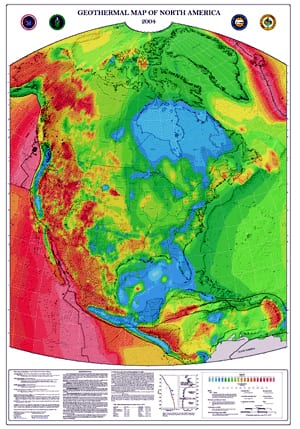
geothermal-map-of-north-america.jpgThe Geothermal Laboratory at SMU has been awarded $5.25 million by the U.S. Department of Energy to help provide data for the planned National Geothermal Data System.

The grant allocation is part of $338 million in Recovery Act funding that was announced Oct. 29 by DOE Secretary Steven Chu. The funding is intended to help dramatically expand geothermal production in the United States.

800px-Geothermal_energy_methods.pngSMU will work with a diverse team of experts from academia, industry and national labs with experience in conventional hydrothermal geothermal resource assessment, Enhanced Geothermal Systems, oil and gas data, geopressure geothermal and produced water non-conventional geothermal systems in providing the data, including:

  • An expanded and updated version of the SMU Heat Flow database that covers the whole onshore U.S. and offshore regions in the Gulf of Mexico.
  • The Geothermal Resources Council library with over 36K in documents and over 1.3 million pages on geothermal research
  • Extensive information on Enhanced Geothermal System research including legacy data files and the latest developing results of research in the northeastern U.S.
  • Core logs, well logs, and current and legacy geopressure data from the Texas Bureau of Economic Geology covering many states
  • Detailed nationwide data on produced water collected from numerous states’ oil and gas agencies and several federal agencies plus relevant geological, spatial, well bore, injection/disposal, and water well data.

blackwell.jpg
Principal investigators are SMU’s David Blackwell, Hamilton Professor of Geothermal Studies, and Fabian Moerchen of Siemens Corporate Research. The project team also includes Jefferson Tester, the Kroll Professor of Chemical Engineering at Cornell University; William Gosnold, chair of geology and geological engineering at the University of North Dakota; Seiichi Nagihara, associate professor of geosciences at Texas Tech University; John Veil, manager of the water policy program at the Argonne National Laboratory and Martin Kay, president of MLKay Technology LLC.

“The primary benefit of this project is that it will support developers of geothermal power plants by decreasing the costs of the resource identification and the risks inherent in the exploration phase,” Blackwell said. “The project will rescue important data from deterioration or complete loss and provide a set of tools to be used by other parties to submit data to the NGDS.”

A distributed network of databases, NGDS was established by the U.S. Department of Energy to collectively build a system for acquisition, management and maintenance of geothermal and related data.

The SMU Geothermal Lab is hosting its annual conference, “Geothermal Energy Utilization Associated with Oil & Gas Development,” Nov. 3-4 on the Dallas campus. Registration is available at the door. Find more information at the conference web site. — Kim Cobb

Related links:
SMU Geothermal Energy Utilization Conference
SECO: Texas Geothermal Energy
Google invests in SMU geothermal research
Google video on advanced geothermal technology
CBN News: Geothermal energy right under our feet
SMU Research News: Earth’s inner heat can generate electric power
SMU geothermal home
SMU Geothermal Laboratory
David Blackwell
Roy M. Huffington Department of Earth Sciences

Categories
Earth & Climate Fossils & Ruins Plants & Animals Researcher news

Polcyn in New Scientist’s “Real Sea Monsters: Hunt for Predator X”

mike-polcyn-sm2.jpg
Paleontologist Michael J. Polcyn, director of the Visualization Laboratory in the SMU Huffington Department of Earth Sciences and SMU adjunct research associate, is quoted as an expert source in “Real Sea Monsters: The Hunt for Predator X.” The article by reporter James O’Donoghue was published in the October 2009 issue of the magazine New Scientist.

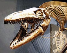
mosasaur1-utmuseum.jpgPolcyn is a world-recognized expert on the extinct marine reptile named Mosasaur.

His research interests include the early evolution of Mosasauroidea and adaptations in secondarily aquatic tetrapods. Polcyn’s research also includes application of technology to problems in paleontology.

Related links:
New Scientist: “Real sea monsters; The hunt for Predator X”
Michael J. Polcyn
video.jpg Discovery Channel: “Mega Beasts: T-Rex of the Deep”
SMU News: Dallasaurus, ancient mosasaur
Huffington Department of Earth Sciences

Categories
Earth & Climate Fossils & Ruins Plants & Animals Slideshows Student researchers

Land snail fossils suggest eastern Canary Islands wetter, cooler 50,000 years ago

Fossil land snail shells found in ancient soils on the subtropical eastern Canary Islands show that the Spanish archipelago off the northwest coast of Africa has become progressively drier over the past 50,000 years.

Isotopic measurements performed on fossil land snail shells resulted in oxygen isotope ratios that suggest the relative humidity on the islands was higher 50,000 years ago, then experienced a long-term decrease to the time of maximum global cooling and glaciation about 15,000 to 20,000 years ago, according to new research by Yurena Yanes, a post-doctoral researcher, and Crayton J. Yapp, a geochemistry professor, both in the Roy M. Huffington Department of Earth Sciences at SMU.

With subsequent post-glacial climatic fluctuations, relative humidity seems to have oscillated somewhat, but finally decreased even further to modern values.

Consequently the eastern Canary Islands experienced an overall increase in dryness during the last 50,000 years, eventually yielding the current semiarid conditions. Today the low-altitude eastern islands are characterized by low annual rainfall and a landscape of short grasses and shrubs, Yanes says.

The research advances understanding of the global paleoclimate during an important time in human evolution, when the transition from gathering and hunting to agriculture first occurred in the fertile Middle East and subsequently spread to Asia, North Africa and Europe.

“In the Canary Archipelago, land snails are one of the rare ‘continuous’ records of paleoclimatic conditions over the last 50,000 years,” Yanes says. “The results of this study are of great relevance to biologists and paleontologists investigating the evolution of plants and animals linked to climatic fluctuation in the Islands.”

The researchers’ isotopic evidence reflects changing atmospheric and oceanic circulation associated with the waxing, waning and subsequent disappearance over the past 50,000 years of vast ice sheets at mid- to high latitudes on the continents of the Northern Hemisphere.

The research also is consistent with the observed decline in diversity of the highly moisture-sensitive land snails.

Land snail shells are abundant and sensitive to environmental change and as fossils they are well-preserved. Measurement of variations in oxygen isotope ratios of fossil shells can yield information about changes in ancient climatic conditions.

The shells are composed of the elements calcium, oxygen and carbon, which are combined to form a mineral known as aragonite. Oxygen atoms in aragonite are not all exactly alike. A small proportion of those atoms is slightly heavier than the majority, and these heavier and lighter forms of oxygen are called isotopes of oxygen.

Small changes in the ratio of heavy to light isotopes can be measured with a high degree of accuracy and precision. Variations in these ratios are related to climatic variables, including relative humidity, temperature and the oxygen isotope ratios of rainwater and water vapor in the environments in which land snails live.

Yanes presented the research at a scientific session of the 2009 annual meeting of The Geological Society of America in Portland, Ore., Oct. 18-21.

The research was funded by the government of Spain’s Ministry of Science and Innovation and the National Science Foundation.