Categories
Earth & Climate Technology

Cockpit audio: Listen as volcanic ash plume causes 1989 engine failure of KLM flight 867

1016225_thumbnail.jpeg
Eyjafjallajokull erupting

Floating ash plumes from Iceland’s Eyjafjallajokull volcano have caused massive disruption to the world’s air traffic, highlighting the danger that volcanic ash plumes pose to aircraft.

The threat from volcanoes has become more severe as the world’s air traffic has increased, and as more people settle closer to volcanoes, says SMU vulcanologist James Quick, a professor in the Southern Methodist University Huffington Department of Earth Sciences.

Quick previously served as program coordinator for the USGS Volcano Hazards Program.

One of the most infamous encounters between a commercial jetliner and a volcano ash plume took place in 1989.
KLM Flight 867, carrying 231 passengers in a Boeing 747, flew into an ash plume after the eruption of Redoubt volcano in Alaska. According to USGS reports, the volcano spewed enormous clouds of ash thousands of miles into the air and nearly caused the airliner to crash.
Captured on audio was the frantic conversation between KLM’s pilot and the Anchorage control tower as the aircraft’s engines began flameout. Hear the cockpit audio in this video, as well as Quick’s comments on the danger.
Volcanic ash plumes can rise to cruise altitudes in a matter of minutes after an eruption, Quick says. Winds carry plumes thousands of miles from the volcanoes and then the plumes are difficult or impossible to distinguish from normal atmospheric clouds.
Quick and other scientists from Southern Methodist University and the U.S. Geological Survey are pioneering technology designed to detect nuclear explosions and enforce the world’s nuclear test-ban treaty to monitor active volcanoes in the Northern Mariana Islands.
Read AOL’s coverage:Determining When The Next One Will Blow
See Guam TV’s coverage:Eye On The Volcano: Could Guam Be The Next Iceland?
Quick on Fox News:Amazing Video Shows Shockwaves Explode From Volcano
Stars and Stripes interviews Quick:Monitoring to track Guam volcanoes
Geology.com news:Volcanoes and Volcanic Eruptions
Worldwide from 1970 to 2000 more than 90 commercial jets have flown into clouds of volcanic ash, causing damage to those aircraft, most notably engine failure, according to airplane maker Boeing.
Volcano monitoring by remote sensing allows USGS scientists to alert the International Civil Aviation Organization’s nine Volcanic Ash Advisory Centers as part of ICAO’s International Airways Volcano Watch program. The centers then can issue early warnings of volcanic ash clouds to pilots.
The islands are near Guam, which soon will be the primary base for forward deployment of U.S. military forces in the Western Pacific.
The two-year, $250,000 project will use infrasound — in addition to more conventional seismic monitoring — to “listen” for signs a volcano is about to blow.
The plan is to beef up monitoring of lava and ash hazards in the Northern Mariana Islands, a U.S. commonwealth.
Read more about the project.
Related links:
SMU Geophysics: Infrasound and seismo-acoustic sensing
NASA: Eruption of Anatahan
USGS: Anatahan volcano
Smithsonian: Anatahan volcano
Northern Mariana Islands
USGS: Volcanic Ash Advisory Centers
Alaska Volcano Observatory
James E. Quick
SMU Huffington Department of Earth Sciences
Dedman College of Humanities and Sciences
Categories
Earth & Climate Fossils & Ruins Plants & Animals Researcher news SMU In The News

SMU’s Polcyn, Jacobs in Discovery Channel’s “Prehistoric Dallas”

Dallas — and much of Texas — was once submerged by a sprawling, blue-water ecosystem called the Western Interior Seaway, which split North America in two from the Gulf of Mexico to the Arctic Ocean, according to a new video documentary by the Discovery Channel.

Prehistoric Dallas” includes commentary from two SMU paleontologists, Michael J. Polcyn and Louis L. Jacobs, both of whom have expertise in Texas’ ancient sea and the life that inhabited it from more than 90 million years ago until the extinction of the dinosaurs at 66 million years ago.

video.jpg Watch “Prehistoric Dallas”

From Dallasaurus to Mosasaur
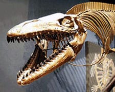
That animal life included the three-foot-long Dallasaurus, which represents an intermediate stage between land-dwelling lizards, similar to the modern day Komodo dragon, and fully marine-adapted Mosasaurs equipped with fin-like limbs and a fish-like tail.

Starting at about 100 million years ago, these small lizards took to the water, but quickly evolved into the huge marine creatures that grew to 50 feet in length by the end of the Cretaceous.

mike-polcyn-sm2.jpg
Michael Polcyn

“(Dallasaurus) probably retained a swimming behavior very similar to what you see in modern lizards,” says Polcyn, whose appearance starts 38 seconds into the “Ocean Pioneer” segment.

The ancient sea covering Texas was clean, deep water, says SMU vertebrate paleontologist Jacobs at the start of the “Texas Submerged” segment. Evidence of that sea exists today in the 86-million-year-old fossils in the geological layer known as the Austin Chalk.

The layer is formed by plankton, Jacobs explains, which are minute organisms that live on the surface of the ocean, then die and filter down to the bottom.

ljacobs.gif
Louis Jacobs

“There was no mud and silt here, washed in from the land,” Jacobs says. “This represents the bottom of the sea, when the sea was at its deepest in this area.”

Polcyn and Jacobs are in the Roy M. Huffington Department of Earth Sciences, Dedman College.

Internationally recognized for his fossil discoveries, Jacobs joined SMU’s faculty in 1983. Currently he has projects in Mongolia, Angola and Antarctica. His book, “Lone Star Dinosaurs” (1999, Texas A&M University Press) was the basis of an exhibit at the Fort Worth Museum of Science and History that traveled the state.

Jacobs consulted on the new exhibit “Mysteries of the Texas Dinosaurs” at the Fort Worth Museum of Science and History. It includes the world’s first skeletal mount of the Texas state dinosaur Paluxysaurus jonesi. Jacobs narrates the video portion of the exhibit, which also includes SMU students Yuri Kimura, Dan Danehy and Kyle Paterson.

Polcyn, director of the Visualization Laboratory in the SMU Huffington Department of Earth Sciences, is an SMU adjunct research associate.

mosasaur1-utmuseum.jpg
Mosasaur skeleton

Polcyn is a world-recognized expert on the extinct marine reptiles called Mosasaurs.

Polcyn’s research also includes application of technology to problems in paleontology.

He recently created computer models to produce life-sized physical models of some of the Paluxysaurus jonesi bones for “Mysteries of the Texas Dinosaurs” at the Fort Worth Museum of Science and History.

Related links:
Louis L. Jacobs
Michael J. Polcyn
Agence France Presse: “Angola: Final frontier for fossils”
New Scientist: “Real sea monsters; The hunt for Predator X”
video.jpg Discovery Channel: “Mega Beasts: T-Rex of the Deep”
SMU News: Dallasaurus, ancient mosasaur
Roy M. Huffington Department of Earth Sciences
Dedman College

Categories
Earth & Climate

SMU-UT study shows “plausible” connection between DFW quakes, saltwater injection well

Production in the Barnett Shale relies on the injection of pressurized water into the ground to crack open the gas-bearing rock, a process known as “hydraulic fracturing.” Some of the injected water is recovered with the produced gas in the form of waste fluids that require disposal.

Long-shot.jpg
SMU scientists place monitoring equipment. Credit: Jackson

The earthquakes do not appear to be directly connected to the drilling, hydraulic fracturing or gas production in the Barnett Shale, the study concludes.

However, re-injection of waste fluids into a zone below the Barnett Shale at the nearby saltwater disposal well began in September 2008, seven weeks before the first DFW earthquakes occurred.

No earthquakes were recorded in the area after the injection well stopped operating in August 2009.

The largest of the DFW-area earthquakes was a 3.3 magnitude event reported by the USGS National Earthquake Information Center.

Fluid injection stressed fault?
A state tectonic map prepared by the Texas Bureau of Economic Geology shows a northeast-trending fault intersects the Dallas-Tarrant county line approximately at the location where the DFW quakes occurred. The study concludes, “It is plausible that the fluid injection in the southwest saltwater disposal well could have affected the in-situ tectonic stress regime on the fault, reactivating it and generating the DFW earthquakes.”

More SMU Research

USGS funds Marianas research

Humans can run 40 mph?

Simulating the Big Bang

An SMU team led by seismologists Brian Stump and Chris Hayward placed portable, broadband seismic monitoring equipment in the area after the earthquakes began.

The seismographs recorded 11 earthquakes between Nov. 9, 2008, and Jan. 2, 2009, that were too small to be felt by area residents. Cliff Frohlich and Eric Potter of UT-Austin joined the SMU team in studying the DFW-area sequence of “felt” earthquakes as well as the 11 “non-felt” earthquakes. Their study, “Dallas-Fort Worth earthquakes coincident with activity associated with natural gas production,” appears in the March issue of The Leading Edge, a publication of the Society of Exploration Geophysicists.

The SMU team also installed temporary monitors in and around Cleburne, Texas where another series of small earthquake began June 2, 2009. Results from that study are not yet available.

Study raises more questions
Stump and Hayward caution that the DFW study raises more questions than it answers.

“What we have is a correlation between seismicity, and the time and location of saltwater injection,” Stump said. “What we don’t have is complete information about the subsurface structure in the area — things like the porosity and permeability of the rock, the fluid path and how that might induce an earthquake.”

“More than 200 saltwater disposal wells are active in the area of Barnett production,” the study notes. “If the DFW earthquakes were caused by saltwater injection or other activities associated with producing gas, it is puzzling why there are only one or two areas of felt seismicity.”

Further compounding the problem, Hayward said, is that there is not a good system in place to measure the naturally occurring seismicity in Texas: “We don’t have a baseline for study.”

Call for more fluid injection research
Enhanced geothermal projects also rely on methods of rock fracturing and fluid circulation. Geological carbon sequestration, an approach being researched to combat climate change, calls for pumping large volumes of carbon dioxide into subsurface rock formations.

“It’s important we understand why and under what circumstances fluid injection sometimes causes small, felt earthquakes so that we can minimize their effects,” Frohlich said.

The study notes that fault ruptures for typical induced earthquakes generally are too small to cause much damage.

“There needs to be collaboration between universities, the state of Texas, local government, the energy industry and possibly the federal government for study of this complicated question of induced seismicity,” Stump said. “Everyone wants quick answers. What I can tell you is the direction these questions are leading us.” — Kimberly Cobb

Click here to read the article

Report Authors:

  • Cliff Frohlich, associate director, senior research scientist, Institute for Geophysics, UT-Austin
  • Eric Potter, program director, Bureau of Economic Geology, UT-Austin
  • Chris Hayward, director, Geophysics Research Projects, Huffington Department of Earth Sciences
  • Brian Stump, Claude C. Albritton Jr. Chair, Huffington Department of Earth Sciences

Related links:
Barnett Shale
hydraulic fracturing
33TV: Five earthquakes in one week
DMN: SMU deploys seismic stations to Cleburne
Brian Stump
Brian Stump and Chris Hayward
Texas Bureau of Economic Geology
USGS National Earthquake Information Center

Categories
Earth & Climate Researcher news Slideshows Technology

USGS-SMU volcano monitoring targets hazard threat to Marianas, U.S. military, commercial jets

Technology designed to detect nuclear explosions and enforce the world’s nuclear test-ban treaty now will be pioneered to monitor active volcanoes in the Northern Mariana Islands near Guam. The island of Guam soon will be the primary base for forward deployment of U.S. military forces in the Western Pacific.

The two-year, $250,000 project of the U.S. Geological Survey and Southern Methodist University will use infrasound — in addition to more conventional seismic monitoring — to “listen” for signs a volcano is about to blow. The plan is to beef up monitoring of lava and ash hazards in the Northern Mariana Islands, a U.S. commonwealth.

The archipelago’s active volcanoes threaten not only residents of the island chain and the U.S. military, but also passenger airlines and cargo ships.

The USGS project calls for installing infrasound devices alongside more traditional volcano monitoring equipment — seismometers and global positioning systems.

SMU Researcher to study human-fire-climate interactions

Scientists at SMU, which the USGS named the prime cooperator on the project, will install the equipment and then monitor the output via remote sensing. The project is a scientific partnership of the USGS, SMU and the Marianas government.

An infrasound experiment
Infrasound hasn’t been widely used to monitor volcanoes, according to noted volcano expert and SMU geology professor James E. Quick, who is project chief. Infrasound can’t replace seismometers but may help scientists interpret volcanic signals, Quick said.

“This is an experiment to see how much information we can coax out of the infrasound signal,” he said. “My hope is that we’ll see some distinctive signals in the infrasound that will allow us to discriminate the different kinds of eruptive styles — from effusive events that produce lava flows, or small explosive events we call vulcanian eruptions, to the large ‘Plinian’ events of particular concern to aviation. They are certain to have some characteristic sonic signature.”

SMU geologists in recent decades pioneered the use of infrasound to monitor nuclear test-ban compliance, and they continue to advance the technology. For the USGS project, they’ll install equipment on three of the Marianas’ 15 islands. In the event magma begins forcing its way upward, breaking rocks underground and ultimately erupting, seismometers will measure ground vibrations throughout the process, GPS will capture any subtle changes or deformities in the surface of the Earth, and infrasound devices will record sound waves at frequencies too low to be heard by humans. Infrasound waves move slower than the speed of light but can travel for hundreds of miles and easily penetrate the earth as well as other material objects.

Volcanoes active on nine islands
Nine Mariana islands have active volcanoes. On average, the archipelago experiences about one eruption every five years, said Quick, who was previously program coordinator of the USGS Volcano Hazards Program.

Most recently a volcano erupted in 2005 on the island of Anatahan, the largest historical eruption of that volcano, according to the USGS. It expelled some 50 million cubic meters of ash, the USGS reported, noting at the time that the volcanic plume was “widespread over the western Philippine Sea, more than 1300 nautical miles west of Anatahan.” A volcano that erupted on the island of Pagan in 1981 has been showing many signs of unrest, Quick said.

Besides the USGS volcano project, SMU has been active in the Marianas through a memorandum of agreement to help the local government search for alternative energy sources, in particular geothermal.

The Marianas volcano project is part of a larger USGS program that is investing $15.2 million of American Recovery and Reinvestment Act funds to boost existing monitoring of high-risk volcanic areas in partnership with universities and state agencies nationwide.

US military deploying to nearby Guam
In targeting the Marianas, the USGS cited the evacuation of residents from the northern islands after the 1981 eruption on Pagan, as well as the threat to the main island of Saipan and to nearby Guam. A U.S. territory, Guam is expected to be home to about 40,000 U.S. military and support personnel by 2014, including 20,000 Marines and dependents redeployed from Okinawa. The Marines will use the island as a rapid-response platform for both military and humanitarian operations. The military also has proposed using the Northern Marianas for military exercises.

The USGS cited also the threat of volcanic ash plumes to commercial and military planes. Air routes connect Saipan and Guam to Asia and the rest of the Pacific Rim, as well as Northeast Asia to Australia, Indonesia, the Philippines and New Zealand.

Worldwide from 1970 to 2000 more than 90 commercial jets have flown into clouds of volcanic ash, causing damage to those aircraft, most notably engine failure, according to airplane maker Boeing.

Volcanic ash hazard to aircraft
Volcanic ash plumes can rise to cruise altitudes in a matter of minutes after an eruption, Quick said. Winds carry plumes thousands of miles from the volcanoes, he explained, and then the plumes are difficult or impossible to distinguish from normal atmospheric clouds.

Monitoring by remote sensing allows USGS scientists to alert the International Civil Aviation Organization’s nine Volcanic Ash Advisory Centers as part of ICAO’s International Airways Volcano Watch program. The centers then can issue early warnings of volcanic ash clouds to pilots.

“Monitoring on the ground gives early warning when an eruption begins, as well as an indication that an eruption might be imminent,” Quick said. “The contribution by the USGS and its university partners for volcano monitoring is to provide that earliest warning — or even a pre-eruption indication — that a volcano is approaching eruption so that the volcanic ash advisory centers can get the word out and alerts can be issued.”

The USGS objective is for infrasound on Saipan, four seismometers on Anatahan, which currently has only one functioning seismometer, two seismometers on Sarigan, and GPS on Anatahan, Sarigan and Saipan.

Safer for residents
Improved monitoring, Quick said, even might allow evacuated islanders to return to their homes — especially understandable for the island of Pagan, given its freshwater lakes, lush forests, black and white sand beaches and abundant fishing.

“A lot of people would like to move back, but it’s considered unsafe absent monitoring,” he said. “If we can establish monitoring networks on these islands, then I think it becomes more practical for people to think about returning. Properly monitored, one should be able to give adequate warning so that people could evacuate.”

Quick is a professor in the SMU Roy M. Huffington Department of Earth Sciences as well as associate vice president for research and dean of graduate studies at SMU. — Margaret Allen

SMU is a nationally ranked private university in Dallas founded 100 years ago. Today, SMU enrolls nearly 11,000 students who benefit from the academic opportunities and international reach of seven degree-granting schools. For more information see www.smuresearch.com. Follow SMU Research on Twitter, @smuresearch.

SMU has an uplink facility located on campus for live TV, radio, or online interviews. To speak with an SMU expert or book an SMU guest in the studio, call SMU News & Communications at 214-768-7650.

Categories
Fossils & Ruins Plants & Animals Researcher news Slideshows

World’s first full skeletal mount of Paluxysaurus jonesi dinosaur reveals new biology

The Early Cretaceous sauropod Paluxysaurus jonesi weighed 20 tons, was 60 feet long and had a neck 26 feet long, according to the scientists who have prepared the world’s first full skeletal mount of the dinosaur.

The massive Paluxysaurus jonesi, prepared for the Fort Worth Museum of Science and History in Fort Worth, was unveiled Nov. 20 when the museum opened in a new $80 million facility. The Paluxysaurus mount enables Texans to see their state dinosaur in three dimensions for the first time.

The reconstructed skeleton is yielding clues to the biology of the animal and its relationship to other similar dinosaurs, says Dale Winkler, lead consultant for anatomy and posture on the skeletal mount.

Winkler is director of the Shuler Museum of Paleontology at SMU and a research professor in the Roy M. Huffington Department of Earth Sciences. Winkler has worked with Paluxysaurus bones since crews from SMU and the Fort Worth museum began to unearth them in the early 1990s.

In preparing the mount, Winkler said he was surprised at how extremely long the neck was — at 26 feet — compared to the tail, and he found the head especially striking.

“It was really exciting to see what the head looked like,” Winkler says. “Paluxysaurus had very high cheeks compared to its relatives. Once the bones defining the opening of the nose were connected, it showed that the nostrils were turned up on top of the snout, instead of out like Brachiosaurus.”

Skeletal mount reveals animal’s anatomy, size and stature
A relative of Brachiosaurus and Camarasaurus, Paluxysaurus lived about 110 million to 115 million years ago. The dinosaur was identified and named in 2007 by Peter J. Rose. The Fort Worth skeleton was assembled from a combination of actual fossil bones from at least four different dinosaurs found on private ranch land in North Central Texas and from cast lightweight foam pieces modeled on original bones. The mount enables scientists to better understand the animal’s anatomy, size and stature on questions like “How were the legs situated, and how did the shoulders relate to the hips?”

From the skeletal mount, the scientists learned that Paluxysaurus was more than 6 feet wide and nearly 12 feet tall at the shoulder, although built fairly light, Winkler says. Its teeth are a lot slimmer than those of its closest relatives, indicating Paluxysaurus gathered and processed food differently, using its teeth not for chewing, but to grab food, he says.

Paluxysaurus had a long neck like Brachiosaurus, and a tail almost as long, but wasn’t quite so gigantic. Scientists also learned Paluxysaurus had relatively long front arms, unlike Diplodocus, making its back more level. The dinosaur’s shoulder turned out fairly high, and the hips were wide, Winkler says, and it had reached a more advanced stage of evolution than Late Jurassic sauropods.

Paluxysaurus’ massive pelvis and its sacrum have never before been viewed by the public, he says. Its ilium, the largest bone in the pelvis, is similar to that of titanosaurids of the Late Cretaceous, mainly found in South America. However, one titanosaurid, called Alamosaurus, entered North America and is known from Big Bend National Park in southwest Texas.

The bones assembled for Fort Worth’s Paluxysaurus mount were recovered by students, faculty, staff and hundreds of volunteers over the past 16 years.

DFW’s ancient Cretaceous past included dinosaurs along a shallow sea
Most bones were found in masses of hardened sandstone dug from a Hood County quarry on the private ranch of Bill and Decie Jones.

It took more than a decade to remove the specimens because they were embedded in a hard sandstone matrix, said Louis L. Jacobs, a world-renowned paleontologist, dinosaur fossil hunter and a professor in the Earth Sciences department at SMU. Jacobs helped unearth and prepare the bones.

The end result is a skeleton that is “absolutely awe-inspiring,” Jacobs says. “Paluxysaurus and the plants and animals it lived among show us the truly unique position Texas held in the Cretaceous world. The exhibits at the Fort Worth museum tell that story to the people who now live where the giants used to walk.”

Sauropods weren’t common during the Early Cretaceous. The Fort Worth specimen is morphologically distinct from all other sauropods described and named in North America at that time, according to the research of Rose, who is now a doctoral student at the University of Minnesota. Rose identified the type specimen and named the animal while a graduate student in geology at SMU.

The Paluxysaurus dinosaurs lived near the shore of the rising Cretaceous seas that eventually covered Texas, amid large-trunked conifer trees that are now extinct. The semi-arid environment nurtured relatives of sago palms but few flowering plants, which were just beginning to spread out across the Earth, Winkler says.

The scientists say the Jones Ranch bone bed is one of the richest accumulations of sauropod bones in North America.

A group apparently died together there in a common death, perhaps a forest fire, according to earlier research of Winkler and Rose.

The quarry has produced hundreds of bones, all within an area of 400 square meters. Fossil hunters found 60 to 70 percent of the bones needed to reconstruct a single Paluxysaurus skeleton, says Aaron Pan, curator of the Fort Worth museum. Most of the bones, however, are too fragile or deformed to be mounted 15 feet in the air, Pan says.

“We were happy to have as much of it as we do,” Pan says, noting that the museum welcomes fossil researchers. “Most of our material is available. So if a researcher did want to see any of it, we’d be happy to have them come.”

Huge, multi-year project recreated skeleton with bones and casts
Paleontologists from both the museum and SMU helped exhibit fabricator and model-maker Robert Reid Studios, located near Fort Worth, mount the bones. About 15 percent to 20 percent of the skeleton is actual fossil bone, while the remaining bones are casts, says Pan.

Preparing the fossils for mounting and modeling was a huge, multi-year project. The cast bones were computer modeled using laser scanning, says Michael J. Polcyn, director of the Earth Sciences department’s image analysis lab at SMU.

“I was able to scan available bones in 3D and manipulate them in the computer to remove distortion, create mirrored pieces — for example right or left — and model missing portions,” Polcyn says. “I was then able to use the computer models to produce life-sized physical models of the bones using computer-controlled machining techniques.”

Many of the very large bones remain all or partially embedded in blocks of quarry rock, due primarily to the logistical challenge of removing them. For example, the 11-ton block containing the pelvis and sacrum required hoisting with an industrial crane. For some large blocks, tons of rock were painstakingly cut with diamond-blade saws from around the various bones to make them manageable in the SMU labs, Winkler says.

Rock was partially removed from the pelvis and sacrum so that Polcyn could scan them. The scientists then constructed a model using dense foam that was cut to form the basic shape. Crews from Robert Reid Studios coated them with epoxy resin to give them hardness, then added a layer of bone texture and painted them to match.

In the case of the long neck, much was preserved, but many of the bones were distorted by sediment load, which essentially crushed the bone, Polcyn says. He studied the neck vertebrae and made a model. Only two of the skull bones were recovered: the left maxilla and a nasal bone, which defined the top front of the face. Polcyn worked closely with a sculptor to reconstruct the skull by studying related groups of dinosaurs.

Preparation of the skeletal mount was funded by the Fort Worth Museum of Science and History. — Margaret Allen

Follow SMUResearch.com on Twitter.

For more information, www.smuresearch.com.

SMU is a nationally ranked private university in Dallas founded 100 years ago. Today, SMU enrolls nearly 11,000 students who benefit from the academic opportunities and international reach of seven degree-granting schools. For more information see www.smu.edu.

SMU has an uplink facility located on campus for live TV, radio, or online interviews. To speak with an SMU expert or book an SMU guest in the studio, call SMU News & Communications at 214-768-7650.