“They’re a ways off from the highway; if nobody mentions it, then nobody is interested in it,” Kermit City Manager Gloria Saenz told the New York Daily News.

Fort Worth Star-Telegram journalist Tom Uhler covered the research of SMU geophysicists Zhong Lu, professor, Shuler-Foscue Chair, and Jin-Woo Kim research scientist, both in the Roy M. Huffington Department of Earth Sciences at SMU. Uhler’s article, “Two giant sinkholes in West Texas expanding, researchers say,” published June 16, 2016.
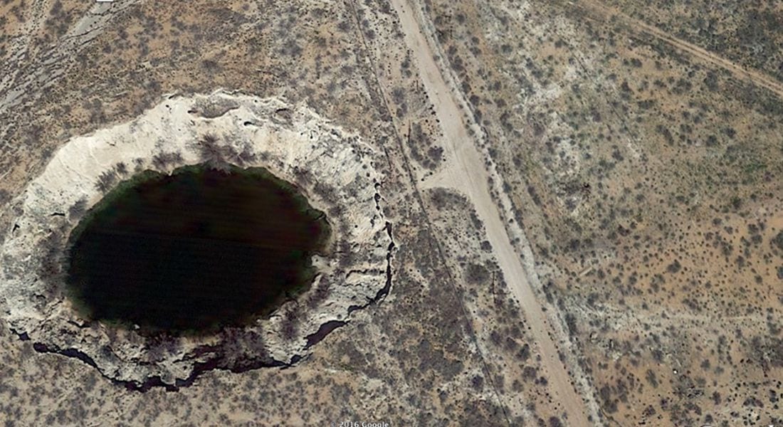
The Dedman College geophysicists are co-authors of a new analysis using satellite radar images to reveal ground movement of two giant sinkholes near Wink, Texas. They found that the movement suggests the two existing holes are expanding, and new ones are forming as nearby subsidence occurs at an alarming rate.
Lu is world-renowned for leading scientists in InSAR applications, short for a technique called interferometric synthetic aperture radar, to detect surface changes that aren’t visible to the naked eye. Lu is a member of the Science Definition Team for the dedicated U.S. and Indian NASA-ISRO InSAR mission, set for launch in 2020 to study hazards and global environmental change.
Request an interview
 To request an interview with Zhong Lu call SMU News and Communications at 214-768-7650 or email SMU News at news@smu.edu.
Request an interview
 To request an interview with Jin-woo Kim call SMU News and Communications at 214-768-7650 or email SMU News at news@smu.edu.
Related links:
- Zhong Lu
- Jin-woo Kim
- Interactive image: Ongoing deformation of sinkholes in Wink, Texas, observed by time-series Sentinel-1A SAR Interferometry
- Roy M. Huffington Department of Earth Sciences
- Dedman College
More SMU Research news
 Early armored dino from Texas lacked cousin’s club-tail weapon, but had a nose for danger
 SMU physicists: CERN’s Large Hadron Collider is once again smashing protons, taking data
 Nearby massive star explosion 30 million years ago equaled brightness of 100 million suns
 Text in lost language may reveal god or goddess worshipped by Etruscans at ancient temple
 Good news! You’re likely burning more calories than you thought
InSAR accesses a series of images captured by a read-out radar instrument mounted on the orbiting satellite Sentinel-1A. Sentinel-1A was launched in April 2014 as part of the European Union’s Copernicus program.
Lu and Kim reported the findings in the scientific journal Remote Sensing, in the article “Ongoing deformation of sinkholes in Wink, Texas, observed by time-series Sentinel-1A SAR Interferometry.”
The research was supported by the U.S. Geological Survey Land Remote Sensing Program, the NASA Earth Surface & Interior Program, and the Shuler-Foscue Endowment at Southern Methodist University.
EXCERPT:
By Tom Uhler
Star-Telegram
A couple of giant sinkholes in the West Texas oil patch are apparently expanding, and might eventually converge into one gigantic hole.The sinkholes are about a mile apart and sit between Wink and Kermit off I-20 west of Midland-Odessa. They were caused by lots of oil and gas extraction, which peaked from the mid-1920s to the mid-1960s, according to researchers at Southern Methodist University.
Satellite radar images indicate that the giant sinkholes are expanding and that new ones are forming “at an alarming rate” as nearby subsidence occurs, they report in the scientific journal Remote Sensing. One is 361 feet across, about the size of a football field; the other is larger, 670 to 900 feet across.
“A collapse could be catastrophic,” said geophysicist Jin-Woo Kim, who leads the SMU geophysical team reporting the findings.
In addition to Wink and Kermit (combined pop. about 7,000), there’s lots of oil and gas production equipment and installations and hazardous liquid pipelines in the area, Kim said in the report. The fresh water injected underground in the extraction process “can dissolve the interbedded salt layers and accelerate the sinkhole collapse.”
There’s something not too dissimilar happening in Daisetta, east of Houston.
Officials have fenced off the area around the sinkholes between Wink and Kermit and they’ll be monitored, but residents don’t appear to be worried about them.
“They’re a ways off from the highway; if nobody mentions it, then nobody is interested in it,” Kermit City Manager Gloria Saenz told the New York Daily News.
A preacher of the Apocalypse from Indiana had a decidedly different take, exclaiming on YouTube: “Here’s my concern. It’s like hell is being enlarged, and that without measure.”
Well, maybe not quite.
Follow SMU Research on Twitter, @smuresearch.
For more SMU research see www.smuresearch.com.
SMU is a nationally ranked private university in Dallas founded 100 years ago. Today, SMU enrolls nearly 11,000 students who benefit from the academic opportunities and international reach of seven degree-granting schools. For more information, www.smu.edu.
SMU has an uplink facility located on campus for live TV, radio, or online interviews. To speak with an SMU expert or book an SMU guest in the studio, call SMU News & Communications at 214-768-7650.