Categories
Earth & Climate Researcher news SMU In The News Subfeature Technology

Wastewater leak in West Texas revealed by satellite radar imagery and sophisticated modeling

Leakage in Ken Regan field could have contaminated groundwater for livestock and irrigation between 2007 and 2011

DALLAS (SMU) – Geophysicists at SMU say that evidence of leak occurring in a West Texas wastewater disposal well between 2007 and 2011 should raise concerns about the current potential for contaminated groundwater and damage to surrounding infrastructure.

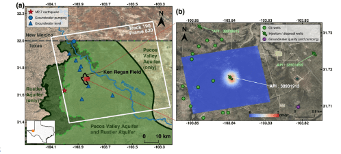
SMU geophysicist Zhong Lu and the rest of his team believe the leak happened at a wastewater disposal well in the Ken Regan field in northern Reeves County, which could have leaked toxic chemicals into the Rustler Aquifer. The same team of geophysicists at SMU has revealed that sinkholes are expanding and forming in West Texas at a startling rate.

a) Coverage of the ALOS PALSAR scenes used (white box). Black line shows the boundary of the Ken Regan field. Dark green line and light green line represent the boundaries of the Rustler Aquifer and Pecos Valley Aquifer in Texas, respectively. Red star represents the epicenter of the earthquake that occurred in May 2018. Blue circle represents the groundwater well for livestock drawing from the Rustler Aquifer in this area. Blue triangles are wells, which provide groundwater leveling records. (b) Vertical deformation (cm/yr) (in the red box in Fig. 1a) estimated from InSAR. Green circles with and without arrows indicate active injection/disposal wells in the Ken Regan field and oil production wells within 1.5 km from the deformation center during the research period, respectively. Purple circle represents the groundwater which provides groundwater quality records. Source: Zhong Lu

Wastewater is a byproduct of oil and gas production. Using a process called horizontal drilling, or “fracking,” companies pump vast quantities of water, sand and chemicals far down into the ground to help extract more natural gas and oil. With that gas and oil, however, come large amounts of wastewater that is injected deep into the earth through disposal wells.

Federal and state oil and gas regulations require wastewater to be disposed of at a deep depth, typically ranging from about 1,000 to 2,000 meters deep in this region, so it does not contaminate groundwater or drinking water. A small number of studies suggest that arsenic, benzene and other toxins potentially found in fracking fluids may pose serious risks to reproductive and development health.

Even though the leak is thought to have happened between 2007 and 2011, the finding is still potentially dangerous, said Weiyu Zheng, a Ph.D. student at SMU (Southern Methodist University) who led the research.

“The Rustler Aquifer, within the zone of the effective injection depth, is only used for irrigation and livestock but not drinking water due to high concentrations of dissolved solids. Wastewater leaked into this aquifer may possibly contaminate the freshwater sources,” Zheng explained.

“If I lived in this area, I would be a bit worried,” said Lu, professor of Shuler-Foscue Chair at SMU’s Roy M. Huffington Department of Earth Sciences and the corresponding researcher of the findings.

He also noted that leaking wastewater can do massive damage to surrounding infrastructure. For example, oil and gas pipelines can be fractured or damaged beneath the surface, and the resulting heaving ground can damage roads and put drivers at risk.     

SMU geophysicists say satellite radar imagery indicates a leak in the nearby disposal well happened because of changes shown to be happening in the nearby Ken Regan field: a large section of ground, five football fields in diameter and about 230 feet from the well, was raised nearly 17 centimeters between 2007 and 2011. In the geology world, this is called an uplift, and it usually happens where parts of the earth have been forced upward by underground pressure.

Lu said the most likely explanation for that uplift is that leakage was happening at the nearby well.

“We suspect that the wastewater was accumulated at a very shallow depth, which is quite dramatically different from what the report data says about that well,” he said.

Only one wastewater disposal well is located in close proximity to the uplifted area of the Ken Regan field. The company that owns it reported the injection of 1,040 meters of wastewater deep into the disposal well in Ken Regan. That well is no longer active.

But a combination of satellite images and models done by SMU show that water was likely escaping at a shallower level than the well was drilled for.

And the study, which was published in the Nature publication Scientific Reports, estimates that about 57 percent of the injected wastewater went to this shallower depth. At that shallower depth, the wastewater–which typically contains salt water and chemicals–could have mixed in with groundwater from the nearby Rustler Aquifer. Drinking water doesn’t come from the Rustler Aquifer, which spans seven counties. But the aquifer does eventually flow into the Pecos River, which is a drinking source.

The scientists made the discovery of the leak after analyzing radar satellite images from January 2007 to March 2011. These images were captured by a read-out radar instrument called Phased Array type L-band Synthetic Aperture Radar (PALSAR) mounted on the Advanced Land Observing Satellite, which was run by the Japan Aerospace Exploration Agency

With this technology called interferometric synthetic aperture radar, or InSAR for short, the satellite radar images allow scientists to detect changes that aren’t visible to the naked eye and that might otherwise go undetected. The satellite technology can capture ground deformation with a precision of sub-inches or better, at a spatial resolution of a few yards or better over thousands of miles, say the researchers.

Lu and his team also used data that oil and petroleum companies are required to report to the Railroad Commission of Texas (Texas RRC), as well as sophisticated hydrogeological models that mapped out the distribution and movement of water underground as well as rocks of the Earth’s crust.

“We utilized InSAR to detect the surface uplift and applied poroelastic finite element models to simulate displacement fields. The results indicate that the effective injection depth is much shallower than reported,” Zheng said. “The most reasonable explanation is that the well was experiencing leakage due to casing failures and/or sealing problem(s).”

“One issue is that the steel pipes can degrade as they age and/or wells may be inadequately managed. As a result, wastewater from failed parts can leak out,” said Jin-Woo Kim, research scientist with Lu’s SMU Radar Laboratory and a co-author of this study.

The combination of InSAR imagery and modeling done by SMU gave the scientists a clear picture of how the uplift area in Regan field developed.

Lu, who is world-renowned for leading scientists in using InSAR applications to detect surface changes, said these types of analysis are critical for the future of oil-producing West Texas.

“Our research that exploits remote sensing data and numerical models provides a clue as to understanding the subsurface hydrogeological process responding to the oil and gas activities. This kind of research can further be regarded as an indirect leakage monitoring method to supplement current infrequent leakage detection,” Zheng said.

“It’s very important to sustain the economy of the whole nation. But these operations require some checking to guarantee the operations are environmentally-compliant as well,” Lu said.

Co-author Dr. Syed Tabrez Ali from AIR-Worldwide in Boston also contributed to this study.

This research was sponsored by the NASA Earth Surface and Interior Program and the Schuler-Foscue endowment at SMU.

Previously, Kim and Lu used satellite radar imaging to find that two giant sinkholes near Wink, Texas—two counties over from the Ken Regan uplift—were likely just the tip of the iceberg of ground movement in West Texas. Indeed, they found evidence that large swaths of West Texas oil patch were heaving and sinking at alarming rates. Decades of oil production activities in West Texas appears to have destabilized localities in an area of about 4,000 square miles populated by small towns like Wink, roadways and a vast network of oil and gas pipelines and storage tanks.

Watch the WFAA Verify news segment. You can also hear a report on the study that was broadcast on Austin’s NPR KUT 90.5 below:


About SMU

SMU is the nationally ranked global research university in the dynamic city of Dallas. SMU’s alumni, faculty and nearly 12,000 students in eight degree-granting schools demonstrate an entrepreneurial spirit as they lead change in their professions, communities and the world.


Categories
Culture, Society & Family SMU In The News Subfeature

NYT: Bickering more after kids?

DALLAS (SMU) – Feel like your fighting more with your spouse after having kids? 

That’s not surprising, given that you have new responsibilities to tackle and you’re probably not getting the sleep you need.

Stephanie Wilson, an SMU assistant psychology professor, told The New York Times that “that lack of sleep is one of the reasons couples spar.” Wilson has researched the relationship between sleep and marital conflict, and found that the worst case scenario for squabbling was when both partners were sleep deprived. If only one partner is exhausted, the bickering isn’t as bad, The NY Times’ Jessica Grose reported.

Read the article to find some great tips for avoiding a relationship apocalypse while you’re raising your children.

About SMU

SMU is the nationally ranked global research university in the dynamic city of Dallas. SMU’s alumni, faculty and nearly 12,000 students in eight degree-granting schools demonstrate an entrepreneurial spirit as they lead change in their professions, communities and the world.


Categories
Researcher news SMU In The News Subfeature

What’s the effect of climate change on plants?

DALLAS (SMU) – Plants need CO2 to live. But we are emitting way too much for plants to absorb.

Bonnie Jacobs

Bonnie Jacobs, a professor of earth sciences at SMU (Southern Methodist University), made this point and others in a recent interview with “Healthy Living Healthy Planet Radio.” Jacobs, who is a noted expert in paleobotany, was asked to weigh in on what climate change might mean for plants in the near future.

By studying fossil plants, paleobotanists can not only better understand past climates, but they can also get a sense of what future climate change could look like.

Jacobs said the climate change we are seeing – precipitated by higher levels of greenhouse gases, especially CO2, emitted into our atmosphere from cars, power plants that burn fuels – will “definitely have a detrimental effect for some plants.”

In some parts of the world, that will be because drought will become more common as the temperature increases, making it harder for native plants to survive. In other parts of the world, it could be because rains become too heavy for plants to grow.

“Life finds ways to adapt.  And if a species cannot adapt, it will go extinct. This is kind of the natural way of the living world,” Jacobs notes. “The really big problem is that we have over 7.5 billion people on this planet right now, and we are living through a very drastic change because the change is happening so quickly with regard to climate.”

You can hear the interview here.


About SMU

SMU is the nationally ranked global research university in the dynamic city of Dallas. SMU’s alumni, faculty and nearly 12,000 students in seven degree-granting schools demonstrate an entrepreneurial spirit as they lead change in their professions, communities and the world.

Categories
Mind & Brain Researcher news SMU In The News Subfeature Videos

Is it possible to change your personality? Yes, if you’re willing to do the work involved

DALLAS (SMU) – Want to be more outgoing?  Or less uptight?

In an interview with Fox4ward’s Dan Godwin, SMU psychology professor Nathan Hudson said that it is possible for people to change aspects of their personality.  But it will require some work on your part.

You can view the video here or on Hudson’s website. Forbes and Psychology Today also did a piece on the research.


About SMU

SMU is the nationally ranked global research university in the dynamic city of Dallas. SMU’s alumni, faculty and nearly 12,000 students in seven degree-granting schools demonstrate an entrepreneurial spirit as they lead change in their professions, community and the world.

Categories
Earth & Climate Researcher news SMU In The News Subfeature

Historical data confirms recent increase in West Texas earthquakes

A new analysis of historical seismic data conducted by The University of Texas at Austin, SMU and other academies has found that earthquake activity in West Texas around Pecos has increased dramatically since 2009.

The study, published Nov. 4, 2019, in the Journal of Geophysical Research: Solid Earth, is important because it leverages old, unmined data to track seismic activity over nearly the past two decades – much further back than other studies— to show that activity has increased during the past decade in an area of the Permian Basin that is being heavily developed for oil and gas. Although researchers have generally thought that to be true, the statewide TexNet earthquake monitoring system has been gathering data since only 2017, making it impossible to definitely determine when the cluster of seismic activity around Pecos really began.

The researchers were able to extend the seismic record of the area by turning to the older TXAR system near Lajitas about 150 miles to the south. TXAR is an array of 10 seismographs installed in the 1990s by scientists at SMU (Southern Methodist University) to help track nuclear testing across the world, said lead author Cliff Frohlich, a senior research scientist emeritus at the University of Texas Institute for Geophysics (UTIG).

“Especially for these West Texas earthquakes, we would like to get some information about when they started,” Frohlich said. “I really saw this as a way to bridge the gap before TexNet.”

The TXAR system is some distance from Pecos, but Frohlich said the equipment is highly sensitive and that the area is remote and seismically very quiet, making the system perfect for picking up vibrations from explosions across the world or from earthquakes 150 miles away. Frohlich worked with Chris Hayward, director of SMU’s Geophysics Research Program, to create a method to derive the earthquake data from the international data TXAR collects and build an earthquake catalog for the Delaware Basin near Pecos from 2000 to 2017.

By analyzing data from 2000 to 2017, scientists were able to document more than 7,000 seismic events near Pecos that were determined by the team to be earthquakes. Data on these seismic events had to be manually reviewed to ensure they were in fact earthquakes and not a false detection. This was done by Frohlich and Julia Rosenblit, who was an SMU intern at the time.

Multiple events first started occurring in 2009, when 19 earthquakes of at least magnitude 1 were documented. The rate increased over time, with more than 1,600 earthquakes of magnitude 1 or greater in 2017. Most were so small that no one felt them.

The study shows a correlation between earthquake activity in the area and an increase in oil and gas activity but doesn’t make an effort to directly tie the two together as other studies have done.

“West Texas now has the highest seismicity rates in the state,” said Heather DeShon, study co-author and associate professor at SMU’s Roy M. Huffington Department of Earth Sciences. “What remained uncertain is when the earthquakes actually started. This study addresses that.”

This study is the latest in a comprehensive effort to determine what is causing an increase in seismic activity in Texas and how oil and gas operations can be managed to minimize that human-induced element. The state approved the TexNet system in 2015, which is operated in tandem with research efforts by the Center for Integrated Seismicity Research (CISR).

Co-author Peter Hennings, who leads CISR and is a Senior Research Scientist at the UT Bureau of Economic Geology said that fundamental research like this latest study is vital when trying to unravel such a complicated problem.

“The obvious next step is exactly what the University of Texas is doing – conducting these careful studies on the relationship between earthquakes and their human and natural causes to build an integrated understanding,” Hennings said.

SMU seismologists have also been the lead or co-authors of a series of studies on Texas earthquakes. For instance, UT Austin and SMU found that earthquakes triggered by human activity have been happening in Texas since 1925, and they have been widespread throughout the state ever since. In addition, SMU research showed that many of the Dallas-Fort Worth earthquakes were triggered by increases in pore pressure–the pressure of groundwater trapped within tiny spaces inside rocks in the subsurface.

The Bureau of Economic Geology and UTIG are units of the UT Jackson School of Geosciences. Scientists from SMU, Portland State University, the University of Oklahoma and the French institute IFREMER also worked on the study.

Several outlets covered the new research, including The Weather Channel, The Dallas Morning News, Texas Tribune, Midland Reporter-Telegram, and Dallas Observer. – The University of Texas at Austin