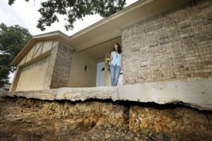
It is significant that underground conditions have changed to trigger slips on a fault line that hasn’t moved in human memory.
Journalist Dylan Baddour covered the recent interim report about the research findings of Southern Methodist University’s seismology team surrounding a recent series of earthquakes in the Irving, Texas area.
His Houston Chronicle report, “New data shows North Texas fault line,” covered the preliminary findings and the progress on the team’s earthquake research.
Book a live interview

Book a live or taped interview with Brian Stump in the SMU Broadcast Studio. Call 214-768-7650; email news@smu.edu. |
Book a live interview

Book a live or taped interview with Heather DeShon in the SMU Broadcast Studio. Call 214-768-7650; email news@smu.edu.
Related links
- Heather DeShon
- Brian Stump
- “Understanding recent North Texas seismicity”
- Roy M. Huffington Department of Earth Sciences
- SMU’s Dedman College
More SMU Research news
 Women who are told men desire women with larger bodies are happier with their weight
 Fossil supervolcano in Italian Alps may answer deep mysteries around active supervolcanoes
 Study: Contraception may change how happy women are with their husbands
 Study funded by NIH is decoding blue light’s mysterious ability to alter body’s natural clock
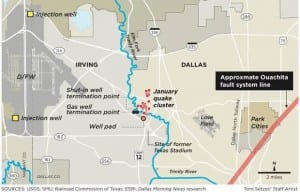
Initial results reveal that the earthquakes that occurred near the site of the old Texas Stadium were relatively shallow and concentrated along a narrow two mile line that indicates a fault extending from Irving into West Dallas.
SMU and the United States Geological Survey shared the report with the mayors of Dallas and Irving spelling out preliminary information gleaned after SMU’s installation in January of more than 20 portable earthquake monitors around the earthquake sites. SMU seismologists Heather DeShon and Brian Stump, in the Roy M. Huffington Department of Earth Sciences, answered questions during the briefing with reporters.
The article published Feb. 11, 2015.
EXCERPT:
By Dylan Baddour
Houston Chronicle
North Texas earthquake swarms still baffle geologists, who never expected to study seismic tremors in the Lone Star State. But last month scientists installed equipment to record quakes near Irving, Texas, and last week the first numbers came in.We still don’t know much about why the region shakes, but here’s what we just learned: the quakes have all been relatively shallow, and have centered along a newly-identified fault line near Irving. The data is thanks 20 seismic monitoring machines, supplied by the U.S. Geological Survey and deployed by scientists from Texas’ Southern Methodist University last month.
“This is a first step, but an important one, in investigating the cause of the earthquakes,” said SMU seismologist Brian Stump. “Now that we know the fault’s location and depth, we can begin studying how this fault moves – both the amount and direction of motion.”
Irving, just north of Dallas, shook first in April 2014, but the area’s strongest quakes struck last month. The so-called “earthquake swarm” follows others since 2008 that have hit North Texas—a region with no history of seismic action. This year, the USGS announced plans to raise the region’s official earthquake risk level. Still, no one knows why the region has started to tremble.
“The two views about them. One: in 150 years there haven’t been natural earthquakes in the Dallas-Fort Worth area, so if these earthquakes were natural, that’s very interesting,” said Cliff Frolich, a geologist at the University of Texas at Austin and a veteran researcher of the North Texas quakes. “On the other hand the earthquakes that occurred in 2008 and subsequently appear to be close to injection wells. The fact that these earthquakes are occurring only a few years later, some people would probably conclude they are related to oil and gas activities.”
Injection wells are where oil and gas drillers dispose of tens of millions of gallons of toxic wastewater left over from hydraulic fracturing, or “fracking,” an extraction technique that’s proliferated in Texas and across the country since 2008. Some scientists have suggested that pressure put on fault lines by high-powered injection into bedrock could trigger the quakes, but nothing is conclusive.
Follow SMUResearch.com on twitter at @smuresearch.
SMU is a nationally ranked private university in Dallas founded 100 years ago. Today, SMU enrolls nearly 11,000 students who benefit from the academic opportunities and international reach of seven degree-granting schools. For more information see www.smu.edu.
SMU has an uplink facility located on campus for live TV, radio, or online interviews. To speak with an SMU expert or book an SMU guest in the studio, call SMU News & Communications at 214-768-7650.
Next step is to investigate what triggered the earthquakes, both natural and man-made.

WFAA Channel 8 reporters Byron Harris and Marjorie Owens covered the recent interim report about the research findings of Southern Methodist University’s seismology team surrounding a recent series of earthquakes in the Irving, Texas area.
The Channel 8 report, “SMU study: Quakes shallow, concentrated at fault line,” covered a briefing with the press on Friday, Feb. 6, to explain progress on the team’s earthquake research.
Book a live interview
|
Book a live or taped interview with Brian Stump in the SMU Broadcast Studio. Call 214-768-7650; email news@smu.edu. |
Book a live interview
Book a live or taped interview with Heather DeShon in the SMU Broadcast Studio. Call 214-768-7650; email news@smu.edu.
Related links
- Heather DeShon
- Brian Stump
- “Understanding recent North Texas seismicity”
- Roy M. Huffington Department of Earth Sciences at SMU
- SMU’s Dedman College
More SMU Research news
Initial results reveal that the earthquakes that occurred near the site of the old Texas Stadium were relatively shallow and concentrated along a narrow two mile line that indicates a fault extending from Irving into West Dallas.
SMU and the United States Geological Survey shared the report with the mayors of Dallas and Irving spelling out preliminary information gleaned after SMU’s installation in January of more than 20 portable earthquake monitors around the earthquake sites. SMU seismologists Heather DeShon and Brian Stump, in the Roy M. Huffington Department of Earth Sciences, answered questions during the briefing with reporters.
The segment aired Feb. 6, 2015.
EXCERPT:
By Byron Harris and Marjorie Owens
WFAA
Southern Methodist University has released preliminary results from a study spurred by the recent earthquakes that have rattled North Texas.The quakes, which have primarily centered near the site of the old Texas Stadium in Irving, “were relatively shallow and concentrated along a narrow two mile line that indicates a fault extending from Irving into West Dallas,” read a statement based on SMU’s findings.
According to the statement, SMU and the United States Geological Survey shared their preliminary findings with the mayors of Dallas and Irving after the university installed 20 portable monitors around the area of the quakes’ epicenters.
“They’re moving a little bit north and they form a linear trend,” said SMU Seismologist Heather DeShon.
Instead of a random pattern of quakes inferred from distant sensors, more-refined data now suggests the January quakes happened in a more focused pattern of major quakes and aftershocks, east and north of the University of Dallas. The scientists estimate the fault that caused the quakes is two miles long and from three-to-five miles deep.
“In order to have an earthquake of 3.6 (as occurred in Irving in January), there has to be a fault there,” Dr. DeShon said.
The study is in its beginning phase, but SMU seismologist said the initial findings are an important start to their investigation.
“We can begin studying how this fault moves – both the amount and direction of motion,” he said.
The seismologists said the reason why the quakes have been felt in far North Texas is because of their relatively close proximity to the surface in the granite “basement.”
Follow SMUResearch.com on twitter at @smuresearch.
SMU is a nationally ranked private university in Dallas founded 100 years ago. Today, SMU enrolls nearly 11,000 students who benefit from the academic opportunities and international reach of seven degree-granting schools. For more information see www.smu.edu.
SMU has an uplink facility located on campus for live TV, radio, or online interviews. To speak with an SMU expert or book an SMU guest in the studio, call SMU News & Communications at 214-768-7650.
Now that SMU’s seismology team has located the fissure, they can begin to study how and why it’s moving.
Science journalist Anna Kuchment covered a recent interim report on the research findings of Southern Methodist University’s seismology team surrounding a recent series of earthquakes in the Irving, Texas area.
Kuchment’s Dallas Morning News article, “Remap of Dallas-area quakes shows fault closer to fracking wells than thought,” covered a briefing with the press on Friday, Feb. 6, to explain progress on the team’s earthquake research.
Book a live interview
|
Book a live or taped interview with Brian Stump in the SMU Broadcast Studio. Call 214-768-7650; email news@smu.edu. |
Book a live interview
Book a live or taped interview with Heather DeShon in the SMU Broadcast Studio. Call 214-768-7650; email news@smu.edu.
Related links
- Heather DeShon
- Brian Stump
- “Understanding recent North Texas seismicity”
- Roy M. Huffington Department of Earth Sciences at SMU
- SMU’s Dedman College
More SMU Research news
 SMU seismologist Brian Stump named AAAS Fellow for distinguished scientific contributions
Initial results reveal that the earthquakes that occurred near the site of the old Texas Stadium were relatively shallow and concentrated along a narrow two mile line that indicates a fault extending from Irving into West Dallas.
SMU and the United States Geological Survey shared the report with the mayors of Dallas and Irving spelling out preliminary information gleaned after SMU’s installation in January of more than 20 portable earthquake monitors around the earthquake sites. SMU seismologists Heather DeShon and Brian Stump, in the Roy M. Huffington Department of Earth Sciences, answered questions during the briefing with reporters.
EXCERPT:
By Anna Kuchment and Avi Selk
Dallas Morning News
Scientists finally have a rough picture of the ancient fault that’s been rattling the Dallas area, and the fissure isn’t where the public thought it was.Armed with more equipment and better data, SMU scientists have relocated dozens of quakes on the federal government’s imprecise maps. The team released a new map on Friday that shifts the epicenters of nearly all of last month’s temblors, arranging them in a neat line that shadows a fissure miles beneath the earth.
And while the team has just begun to study that fault, they already have some early hints about its nature.
It’s not beneath the old Texas Stadium site, as federal maps suggested.
It’s small (for a fault) and appears to be quieting down after tossing off about four dozen quakes in a year. But it could still produce a tremor much more powerful than any Dallas has yet seen.
And while scientists are skeptical that gas drilling woke it up, they now know the fault runs much closer than previously thought to the only two fracking wells in the area.
If you’ve felt any of the earthquakes to hit the Dallas area since last fall, you may have looked up a map of their epicenters. The rough bull’s eye of quakes around the old Texas Stadium site has sparked wild theories about the stadium’s demolition and jokes about the “Jerry Jones Fault.”
That map is wrong, and scientists have always known it.
The federal government estimated the North Texas epicenters using a small handful of quake detectors, some of which sat miles away and produced inaccurate readings.
The U.S. Geological Survey’s blob of approximate quake locations was of little use to scientists trying to map the underground crack producing them. So in early January, the SMU team began to install nearly two dozen detectors in the Irving area to collect more accurate data.
The earth obliged with more than two dozen quakes since then, including the most powerful yet in Dallas County.
Follow SMUResearch.com on twitter at @smuresearch.
SMU is a nationally ranked private university in Dallas founded 100 years ago. Today, SMU enrolls nearly 11,000 students who benefit from the academic opportunities and international reach of seven degree-granting schools. For more information see www.smu.edu.
SMU has an uplink facility located on campus for live TV, radio, or online interviews. To speak with an SMU expert or book an SMU guest in the studio, call SMU News & Communications at 214-768-7650.
Shallow depths explain why so many felt relatively small quakes; not unusual for earthquakes to occur at different fault levels.

Initial results from the seismology team at Southern Methodist University reveal that a recent series of North Texas earthquakes occurring near the site of the old Texas Stadium in the Dallas-Fort Worth area were relatively shallow and concentrated along a narrow two mile line that indicates a fault extending from Irving into West Dallas.
SMU and the United States Geological Survey on Friday, Feb. 6, 2015 shared an interim report with the mayors of Dallas and Irving spelling out preliminary information gleaned after SMU’s installation in January of more than 20 portable earthquake monitors around the earthquake sites.
Book a live interview
|
Book a live or taped interview with Brian Stump in the SMU Broadcast Studio. Call 214-768-7650; email news@smu.edu. |
Book a live interview
Book a live or taped interview with Heather DeShon in the SMU Broadcast Studio. Call 214-768-7650; email news@smu.edu.
Related links
- Heather DeShon
- Brian Stump
- “Understanding recent North Texas seismicity”
Matthew Hornbach - Maria Beatrice Magnani
- Chris Hayward
- Roy M. Huffington Department of Earth Sciences at SMU
- SMU’s Dedman College
More SMU Research news
“This is a first step, but an important one, in investigating the cause of the earthquakes,” said SMU seismologist Brian Stump. “Now that we know the fault’s location and depth, we can begin studying how this fault moves — both the amount and direction of motion.”
“Then we can move on to what might have triggered it – examining factors both natural and manmade,” said SMU seismologist Heather DeShon. “Sometimes what triggers an earthquake can be very small, so all of these factors have to be considered when looking for that trigger.”
The earthquakes have occurred in the granite “basement,” below the layers of sedimentary rock that make up the large geological formation known as the Fort Worth Basin, at depths between 4.5 and 7 kilometers, according to the report. It is not unusual for earthquakes to occur at different levels on a fault. Those depths are considered relatively close to the surface in earthquake terms, however, which helps explain why people as far away as the northern suburb of Plano feel even smaller magnitude 2 earthquakes in the area.
January 2015 earthquakes actually have occurred along a line from Irving to West Dallas
The USGS initially mapped the earthquake locations as being spread out in a roughly circular area centered on the old Texas Stadium site, developing those locations from data collected by distant seismic monitors ranging from the closest at about 40 miles away to as far as 900 miles away. But once SMU installed more than 20 monitors in the immediate area – supplied by the USGS and the academic consortium IRIS – the enhanced data they were able to retrieve shows the January 2015 earthquakes actually have occurred along a line from Irving to West Dallas, running north-by-northeast from TX Highway 114 to Walnut Hill Road along the Trinity River.
That line indicates the approximate location of a subsurface fault.
This initial mapping of the fault provides important information for municipal hazard assessment in Irving and Dallas, Stump said, allowing city officials to know which parts of their cities might experience the worst shaking if the fault remains active. As has been the case with other earthquake sequences in North Texas since 2008, this latest bout of seismic activity appears to be diminishing over time. But SMU scientists stress that there is no way to predict when the series will end, or what the largest magnitude will be.
The earthquakes in the Irving area began in April 2014. SMU scientists had just installed the first of its local monitors in the city of Irving on Jan. 5, 2015 when the area recorded its two largest earthquakes – 3.5 and 3.6 magnitude events – on Jan. 6.
SMU seismology team installed more than 20 seismographs in the affected area
During January, members of the SMU seismology team installed more than 20 seismographs in the affected area, including 12 short-term units that had to be removed from the field to collect their data. There will be 11 temporary seismographs running as part of the Irving network moving forward.
The report notes the presence of two wells drilled for shale gas (only one was put into production, last producing in 2012) near the earthquake epicenters and the location of a wastewater injection well approximately eight miles to the northwest. Production and disposal activities in this region are generally confined to the sedimentary layers above the “basement” layers where regional earthquakes have occurred.
“Scientific questions about the nature of events in North Texas have heightened local and national concerns about the impact of activities related to shale gas production on geological infrastructure and subsurface infrastructure,” the report reads. “SMU scientists continue to explore all possible natural and anthropogenic (due to human activity) causes for the Irving earthquakes and do not have a conclusion at this time.”
The next steps of the Irving study already are underway.
Signing the report were Heather DeShon, SMU associate professor of geophysics; Brian Stump, SMU Albritton Chair of Geological Sciences; Chris Hayward, senior scientist and director of SMU’s Geophysics Research Program; Beatrice Magnani, SMU associate professor of geophysics; Matthew Hornbach, SMU associate professor of geophysics; and Robert Williams and Michael Blanpied of the USGS Earthquake Hazards Program. — Kimberly Cobb
Follow SMUResearch.com on twitter at @smuresearch.
SMU is a nationally ranked private university in Dallas founded 100 years ago. Today, SMU enrolls nearly 11,000 students who benefit from the academic opportunities and international reach of seven degree-granting schools. For more information see www.smu.edu.
SMU has an uplink facility located on campus for live TV, radio, or online interviews. To speak with an SMU expert or book an SMU guest in the studio, call SMU News & Communications at 214-768-7650.

Journalist Jehadu Abshiro of the SMU Daily Campus covered the research of SMU seismologist Heather R. DeShon.
DeShon is leading the effort to trace the source of a recent sequence of small earthquakes in North Texas and any relationship they may have to the injection of waste water by energy companies using shale gas production to recover gas.
North Texas earthquakes occurring in the Reno-Azle area since Nov. 5, 2013, and in Mineral Wells since Nov. 28, 2013, have raised scientific questions about the nature of these sequences and heightened local and national concerns about the impact of shale gas production on infrastructure and subsurface structures.
The Daily Campus article published Feb. 9, “SMU seismologists investigate cause of North Texas earthquakes.”
DeShon, an associate professor of geophysics, is an expert in earthquake generation within subduction zones and intraplate settings, seismogenic zone processes, local earthquake tomography and volcano seismology.
EXCERPT:
By Jehadu Abshiro
The Daily Campus
The Reno-Azle area, west of Fort Worth, has been experiencing more than 30 earthquakes since November, according to the U.S. Geological Survey.The largest earthquake was 3.7 on the Richter scale. The majority of the earthquakes are at a low magnitude.
“The real question is how big can these earthquakes get,” said Christopher Hayward, director of geophysics research at SMU.
A group of 12 SMU scientists and students, a well as a Lake Highlands High School intern, are currently studying the Reno-Azle area.
Associate geophysics professor Heather DeShon is leading the study and Hayward is leading the installation process. The group has installed 12 instruments so far.
Questions whether the earthquakes are occurring because of fracking by oil and gas companies lead a group of Azle, Texas residents to travel to the state capitol Jan. 23.
“It is important we do not rush to conclusions,” DeShon said at a press conference Friday. “I understand people want results quickly. But we have to sit and wait a little while.”
Fracking is the injection of water, sand and chemicals under high pressure into bedrock to increase the flow of oil or gas. Of the about 35,000 shale gas wells in the U.S., only two cases show fracking-induced seismicity.
According to Hayward, the wastewater injection wells are more of a concern. Wastewater injection wells, about 30,000 in the U.S., dispose of waste fluids from producing oil and gas wells by injection wells drilled below fresh water aquifers. According to Induced Seismicity Potential in Energy Technologies, there were eight case studies linking earthquakes to these wastewater wells in the U.S. in 2011.
Wastewater disposal is a separate process from the fracking operation and may occur away from the fracked well.